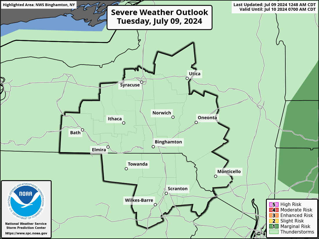
CENTRAL NEW YORK SEVERE WEATHER ALERTS
Click Image For Front LIVEcam
Click Image For Back LIVEcam
Click Image For Radar Loop
CNYWeather Live Cam
CNYWeather Snow Stick Live Cam
Local Doppler Radar Display
No Weather Records Have Been Established For This Station Today as of 05:40 AM

CENTRAL NEW YORK HOURLY  FORECAST
6:00 AM 8:00 AM 10:00 AM 12:00 PM 2:00 PM 4:00 PM 6:00 PM
Rain Showers Rain Showers Rain Showers Rain Showers Rain Showers Rain Showers Chance of Rain
 49°  46°  46°  46°  46°  52°  53°
NW 11 mph NW 11 mph NW 14 mph NW 15 mph NNW 16 mph NNW 15 mph NW 14 mph
POP 80% POP 80% POP 80% POP 80% POP 80% POP 80% POP 80%
   Data courtesy of WeatherUnderground

Live Conditions Updated: 05/24/2013 @ 5:40:00 am  
Temperature Current Conditions National Weather Service Forecast
Currently:

44.9°F

Trend:Colder 1.5°F than last hour. /hr
Wind Chill   42°F
24-hr difference
-19.3°FColder 19.3°F than yesterday at this time.
---
High Today
61.6°F
12:16am
Low Today
44.9°F
5:37am
Last Year
79.6°F
Last Year
60.1°F
Normal High
68°F
Normal Low
48°F
*Griffiss Airport Records
Record High
89°F
1991
Record Low
34°F
1992
Station Records Since 2006
Record High
86.7°F
2010
Record Low
41.9°F
2008


At Griffiss Airport
overcast - light rain; mist

Wind from NW NW  
5.1
Gust:
9.0
Light Breeze
Max Gust: 20.0 mph 1:54am
Month: 38.0 mph May 21
Year: 41.4 mph on Jan 10
Today

Showers. Chance for Measurable Precipitation 80%
Showers

Hi 51 °F
Saturday

Isolated Showers. Chance for Measurable Precipitation 20%
Isolated
Showers
Hi 58 °F
Sunday

Breezy
Breezy

Hi 63 °F
Tonight

Showers Likely. Chance for Measurable Precipitation 60%
Showers
Likely
Lo 38 °F
Saturday
Night

Partly Cloudy
Partly
Cloudy
Lo 38 °F
Sunday
Night

Partly Cloudy
Partly
Cloudy
Lo 41 °F

Click here for full NWS Forecast
Dew Point Liquid Precipitation Wind Sun/Moon
Dew Point: 43.6°F Decreased 1.5°F since last hour.
In Last Hour: -1.5°F
High Dew
Point:
60.4°F
at 12:16 AM
Low Dew
Point:
43.6°F
at 5:37 AM
Wetbulb: 44.3°F
Today: 0.41 in
Rate (/hr): 0.02 in
Storm Rain: 2.03 in
Yesterday: 0.37 in
Last 7 Days: 1.90 in
May Rain: Under 0.42 in for the month 2.53 in
May Avg: 2.95 in
Diff from Avg: -0.42 in
Rain Season:1 12.91 in
Last YTD Rain:1 13.58 in
70 rain days in 2013
12 days in May
0 day since last rain
Currently: NW at
5.1 mph
Gusting To: 9.0
Max Gust: 20.01:54 AM
1Hr Average: 5.4 mph
Max Gust
This Month:
38.0 mph
on  May 21
Wind Run: 26.62 miles
Daylight:
Possible hours of Daylight
14:58:00

+00:01:45
Minutes

Waxing Gibbous, 14 days, 9 hours, 16 minutes in cycle
99%
Illuminated
Humidity Barometer
Humidity: No Change 95 %
In Last Hour: 0%
High
Today
96%
at 12:00 AM
Low
Today
92%
at 3:35 AM
Current: Rising 0.03 °F/hr 29.846 inHg
In Last Hour: Rising
High
Today:
29.846
at 5:39 AM
Low
Today:
29.720
at 12:54 AM
Heating Degree Days Snow3 Wind Chill Air Quality
Today: 1.9
May: 158.2
2013 to Date: 4104.3
Cooling Degree Days
2013 to Date: 19.4
Today: 0.0 in
Yesterday: 0.0 in
May: No Change 0.0 in
May Avg: 0.0 in
Diff from Avg: 0.0 in
Season Total:2 81.4 in
Snow Depth: 0.0 in
0 snow day in May
52 snow days this season.2
Current: 42.1°F
Today: 40.5°F  at 5:30 AM
Yesterday: 61.3°F
Record: -26.1°F
Mar-6-2007
Quality
Index:

7


Good
Density:
1.252 kg/m3
UV Summary/Forecast Current Solar Energy
May-24

7.3
May-25

7.0
May-26

6.8
0 W/m2
0 %
Highest:
12:00 AM
0
Almanac Indoor Station All Time Records Cloud Level
Currently: Night
YTD Avg Temp: 36.2°F
Sunrise: 5:29 AM
Sunset: 8:27 PM
Moonrise: 6:56 PM
Moonset: 5:00 AM
Full Moon: 25 May 2013
New Moon: 15:57 UTC 8 June 2013
Current: 67.4°F 
Past Hour: -1.5°F 
High: 74.9°F  at 12:00am
Low: 67.4°F  at 5:36am
Humidity 41%
Irrigation Index:5
Current ET: 0.02 in   
7-Days: 1.90 in   
7-Days ET: 1.01 in   
7-Day: 0.895 in 0.895 in water in excess of what evaporated in last 7 days.
HIGHS: LOWS:
96.8°F
Jul-21-2011
-21.5°F
Jan-24-2011
Day Records 6am-6pm
    90.1°F
01-Sep-2007
  -1.5°F
24-Jan-2011
Night Records 6pm-6am
  83.3°F
22-Jul-2011
-14.4°F
24-Jan-2013
ICN:5 | ISS:Ok | CON:4.5 | RCP:99%
1 Rain season: Jan 1st to Dec 31st.    2 Snow season July 1st to June 30th.    3 Snow manually measured usually around 7AM and 7PM.   
5 Estimated amount of water needed to replace the water used by plants and evaporation from the past week. (Negative numbers mean amount of water needed, positive numbers mean excess water is present.) Air Quality Index is provided by Minnesota Polution Control Agency and is updated hourly between the hours of 6AM and Midnight.
Modified Dashboard Version 6.20 27-Jun-2011 - Script Mods by: WebsterWeatherLIVE.com

USA Weather Finder
United States Weather Group
Weather Topsites

 eXTReMe Tracker