

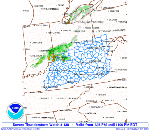
SPC Tornado Watch 138
WW 138 TORNADO OK 261035Z - 261600Z


URGENT - IMMEDIATE BROADCAST REQUESTED
Tornado Watch Number 138
NWS Storm Prediction Center Norman OK
535 AM CDT Fri Apr 26 2024

The NWS Storm Prediction Center has issued a

* Tornado Watch for portions of
  Eastern Oklahoma

* Effective this Friday morning from 535 AM until 1100 AM CDT.

* Primary threats include...
  A few tornadoes possible
  Scattered damaging wind gusts to 70 mph possible
  Isolated large hail events to 1 inch in diameter possible

SUMMARY...A squall line with embedded bowing segments/mesovortices
will pose a continued threat for a couple of tornadoes, damaging
gusts of 60-70 mph and isolated large hail near 1 inch diameter
through mid morning.

The tornado watch area is approximately along and 45 statute miles
east and west of a line from 25 miles east northeast of Tulsa OK to
35 miles east southeast of Mcalester OK. For a complete depiction of
the watch see the associated watch outline update (WOUS64 KWNS
WOU8).

PRECAUTIONARY/PREPAREDNESS ACTIONS...

REMEMBER...A Tornado Watch means conditions are favorable for
tornadoes and severe thunderstorms in and close to the watch
area. Persons in these areas should be on the lookout for
threatening weather conditions and listen for later statements
and possible warnings.

&&

OTHER WATCH INFORMATION...CONTINUE...WW 137...

AVIATION...Tornadoes and a few severe thunderstorms with hail
surface and aloft to 1 inch. Extreme turbulence and surface wind
gusts to 60 knots. A few cumulonimbi with maximum tops to 500. Mean
storm motion vector 25040.

...Thompson


Read more
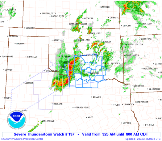
SPC Severe Thunderstorm Watch 137
WW 137 SEVERE TSTM OK TX 260825Z - 261300Z


URGENT - IMMEDIATE BROADCAST REQUESTED
Severe Thunderstorm Watch Number 137
NWS Storm Prediction Center Norman OK
325 AM CDT Fri Apr 26 2024

The NWS Storm Prediction Center has issued a

* Severe Thunderstorm Watch for portions of
  Southern Oklahoma
  Extreme north Texas

* Effective this Friday morning from 325 AM until 800 AM CDT.

* Primary threats include...
  Scattered damaging wind gusts to 70 mph possible
  Scattered large hail events to 1.5 inches in diameter possible
  A tornado or two possible

SUMMARY...A line of storms appears to be organizing near and north
of the Red River, and these storms will spread east-northeastward
through the early morning hours.  Damaging winds of 60-70 mph will
be the main threat, along with occasional large hail of 1-1.5 inches
in diameter.  A tornado or two will also be possible with
circulations embedded in the line.

The severe thunderstorm watch area is approximately along and 60
statute miles north and south of a line from 20 miles south
southwest of Fort Sill OK to 55 miles north northeast of Durant OK.
For a complete depiction of the watch see the associated watch
outline update (WOUS64 KWNS WOU7).

PRECAUTIONARY/PREPAREDNESS ACTIONS...

REMEMBER...A Severe Thunderstorm Watch means conditions are
favorable for severe thunderstorms in and close to the watch area.
Persons in these areas should be on the lookout for threatening
weather conditions and listen for later statements and possible
warnings. Severe thunderstorms can and occasionally do produce
tornadoes.

&&

OTHER WATCH INFORMATION...CONTINUE...WW 135...

AVIATION...A few severe thunderstorms with hail surface and aloft to
1.5 inches. Extreme turbulence and surface wind gusts to 60 knots. A
few cumulonimbi with maximum tops to 500. Mean storm motion vector
25040.

...Thompson


Read more
SPC Tornado Watch 138 Status Reports
WW 0138 Status Updates


STATUS REPORT ON WW 138

SEVERE WEATHER THREAT CONTINUES RIGHT OF A LINE FROM 35 S MLC TO
20 SE MLC TO 25 ENE MLC TO 25 W RKR TO 20 NW RKR TO 30 WNW FSM TO
25 NNW FSM TO 30 SSW UMN.

..JEWELL..04/26/24

ATTN...WFO...TSA...


STATUS REPORT FOR WT 138

SEVERE WEATHER THREAT CONTINUES FOR THE FOLLOWING AREAS

OKC077-079-127-135-261440-

OK
.    OKLAHOMA COUNTIES INCLUDED ARE

LATIMER              LE FLORE            PUSHMATAHA
SEQUOYAH


THE WATCH STATUS MESSAGE IS FOR GUIDANCE PURPOSES ONLY.  PLEASE
REFER TO WATCH COUNTY NOTIFICATION STATEMENTS FOR OFFICIAL
INFORMATION ON COUNTIES...INDEPENDENT CITIES AND MARINE ZONES
CLEARED FROM SEVERE THUNDERSTORM AND TORNADO WATCHES.


Read more
SPC Severe Thunderstorm Watch 137 Status Reports
WW 0137 Status Updates


STATUS REPORT ON WW 137

SEVERE WEATHER THREAT CONTINUES RIGHT OF A LINE FROM SPS TO 20
NNW ADM TO 40 W MLC TO 25 SE CQB.

..GUYER..04/26/24

ATTN...WFO...OUN...FWD...


STATUS REPORT FOR WS 137

SEVERE WEATHER THREAT CONTINUES FOR THE FOLLOWING AREAS

OKC005-013-019-029-063-067-069-085-095-099-123-261340-

OK
.    OKLAHOMA COUNTIES INCLUDED ARE

ATOKA                BRYAN               CARTER
COAL                 HUGHES              JEFFERSON
JOHNSTON             LOVE                MARSHALL
MURRAY               PONTOTOC


TXC077-097-181-337-261340-

TX
.    TEXAS COUNTIES INCLUDED ARE

CLAY                 COOKE               GRAYSON
MONTAGUE


THE WATCH STATUS MESSAGE IS FOR GUIDANCE PURPOSES ONLY.  PLEASE
REFER TO WATCH COUNTY NOTIFICATION STATEMENTS FOR OFFICIAL
INFORMATION ON COUNTIES...INDEPENDENT CITIES AND MARINE ZONES
CLEARED FROM SEVERE THUNDERSTORM AND TORNADO WATCHES.


Read more
SPC MD 524
MD 0524 CONCERNING TORNADO WATCH 138... FOR EASTERN OK TO SOUTHWEST MO/WESTERN AR
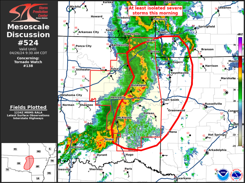
Mesoscale Discussion 0524
NWS Storm Prediction Center Norman OK
0735 AM CDT Fri Apr 26 2024

Areas affected...Eastern OK to southwest MO/western AR

Concerning...Tornado Watch 138...

Valid 261235Z - 261430Z

The severe weather threat for Tornado Watch 138 continues.

SUMMARY...Severe thunderstorms including the potential for primarily
damaging winds and a couple tornadoes continues across eastern
Oklahoma, and may develop into far western Arkansas and possibly
southwest Missouri. Tornado Watch 138 continues for eastern
Oklahoma, and downstream Arkansas/southwest Missouri areas are being
monitored for possible but uncertain Watch issuance in the short
term.

DISCUSSION...A well-organized squall line with
LEWP/northern-peripheral bowing characteristics continues across
eastern Oklahoma, with bow-related northeastward storm motions
around 50 kt. The most intense portion of the squall line and
greatest short-term severe risk should be focused where the
convective line intercepts the warm front (and just a bit north
thereof) in the general vicinity of I-40 in far eastern Oklahoma
into west/northwest Arkansas. Farther north, the severe-potential
longevity of the surging bowing portion of the line is a bit more
uncertain with northward extent, given that the bowing line will
gradually encounter an increasingly more stable boundary layer (0.5
km AGL deep per 12z Springfield MO observed sounding).

..Guyer.. 04/26/2024

...Please see www.spc.noaa.gov for graphic product...

ATTN...WFO...LZK...SGF...SHV...TSA...OUN...

LAT...LON   36019526 36629549 37029389 35829350 34309458 34369589
            35219576 36019526
Read more
SPC Apr 26, 2024 1300 UTC Day 1 Convective Outlook
SPC 1300Z Day 1 Outlook


Day 1 Convective Outlook
NWS Storm Prediction Center Norman OK
0753 AM CDT Fri Apr 26 2024

Valid 261300Z - 271200Z

...THERE IS AN ENHANCED RISK OF SEVERE THUNDERSTORMS THIS
AFTERNOON/EVENING ACROSS NORTHEAST KS/SOUTHEAST NE/NORTHWEST
MO/SOUTHWEST IA...

...SUMMARY...
A few tornadoes, including a couple of strong tornadoes, isolated
very large hail (greater than 2 inch diameter) and isolated wind
damage will be possible, mainly this afternoon/evening from
northeast Kansas/southeast Nebraska into northwest Missouri and
southwest Iowa.  Occasional severe storms are expected farther south
into Arkansas, eastern Oklahoma and northeast Texas.

...Mid MO Valley to TX through tonight...
A complex surface pattern is evident this morning with a cyclone in
northern KS, a trailing dryline/Pacific front into western OK, and
the east edge of the warm sector demarcated by a warm front from
eastern OK into eastern KS.  An ongoing QLCS with occasional wind
damage and tornado reports is moving across eastern OK near the warm
front, with an area of rain-cooled/overturned in OK in the wake of
these storms.  Farther north, an undisturbed portion of the warm
sector extends across central KS.

The eastern OK convection will likely persist through the day toward
western AR, with additional expansion of rain/thunderstorms farther
northeast into southwest/central MO.  The OK/AR portion of this
convection will be the most likely to maintain access to the surface
warm sector through the day, where a mix of bowing segments or
embedded supercells will be possible with all hazards.

The clouds/rain will slow the northeastward progress of the warm
sector, and northward advection of the overturned airmass in OK will
potentially impact the breadth and quality of the unstable warm
sector this afternoon.  Assuming sufficient recovery during the day,
there will be a window of opportunity for tornadic supercells along
the dryline this afternoon/evening starting in northeast
KS/southeast NE and spreading into northwest MO/southwest IA.
MLCAPE at or above 2000 J/kg, boundary-layer dewpoints in the mid
60s, and sufficiently long hodographs with low-level hodograph
curvature (effective bulk shear in excess of 50 kt, and effective
SRH of 200-300 m2/s2) suggest the potential for a couple of strong
tornadoes with any persistent, semi-discrete supercells.  Isolated
very large hail (in excess of 2 inches in diameter) will also be
possible, while the potential for a few damaging gusts will
accompany any upscale growth into line segments this evening.

Additional thunderstorm development will be possible today farther
southwest into TX, in association with weak height falls on the
southern fringe of the ejecting midlevel trough.  The 12z FWD
sounding showed only a weak cap, so the SLGT has been expanded some
to the southwest to account for large hail/wind damage potential
today.  Storms will likely weaken by this evening as weak height
rises commence and the remnant dryline begins to retreat to the
west.

..Thompson/Guyer.. 04/26/2024


Read more
SPC Apr 26, 2024 Day 4-8 Severe Weather Outlook
Day 4-8 Outlook


Day 4-8 Convective Outlook
NWS Storm Prediction Center Norman OK
0349 AM CDT Fri Apr 26 2024

Valid 291200Z - 041200Z

...DISCUSSION...
A less amplified flow regime is expected to evolve through at least
early next week, with the strongest mid/upper-level westerlies
generally confined to the northern CONUS. However, a reservoir of
rich low-level moisture will persist across the southern Plains and
lower MS Valley, which may occasionally be drawn northward in
response to shortwave troughs moving through the primary belt of
westerlies. While no synoptically evident severe thunderstorm
episodes are currently apparent in extended-range guidance, some
threat could evolve each day through at least mid week.

...D4/Monday - Southern Plains into the ArkLaTex region...
Guidance generally suggests that a low-amplitude shortwave trough
will move across the southern Plains on Monday, though timing
remains somewhat uncertain. If the shortwave ends up being favorably
timed with the diurnal cycle, then a few strong to severe storms
will be possible from eastern portions of the southern Plains into
the lower MS Valley, with large hail and locally gusty winds likely
being the primary threats.

...D5/Tuesday - Great Plains into the upper Midwest...
Most extended-range guidance depicts a relatively strong shortwave
trough and attendant surface low moving across the northern Plains
on Tuesday. While stronger deep-layer flow/shear and large-scale
ascent will likely be displaced north of the more favorable
instability, a few strong storms could develop along the trailing
cold front somewhere from the central Plains into the upper Midwest.

...D6/Wednesday - Parts of the central/southern Plains...
The cold front that moves southeastward through the Great Plains
region on Tuesday will likely stall on Wednesday and potentially
move northward as a warm front, though guidance varies regarding the
placement of this boundary. Rich low-level moisture and moderate to
strong buoyancy will be in place along/south of the boundary during
the afternoon, and modest westerly flow aloft may be marginally
sufficient for a few strong to severe storms.

...D7/Thursday into D8/Friday...
There is some potential for a stronger cold front to move into parts
of the southern Plains and Southeast by the end of the week, though
spread in extended-range guidance notably increases at this forecast
range. If a stronger front does materialize, some strong to severe
thunderstorms could accompany the front, with generally dry and
stable conditions in its wake.


Read more